Browse Maps
| map | Title | Year | Last Updated  |
Status |
|---|---|---|---|---|

|
General-content county map showing townships, rural buildings, and householders' names; the city/borough insets show building coverage and some occupants' names.
Links: Source / Biblio Ref
|
1860 | about 1 hour ago | 48 control points |

|
|
2026 | about 2 hours ago | 5 control points |

|
|
2026 | about 5 hours ago | Unrectified |

|
|
2026 | about 7 hours ago | Unrectified |

|
|
2026 | about 7 hours ago | 31 control points |

|
|
1981 | about 7 hours ago | 4 control points |

|
|
2024 | about 8 hours ago | 3 control points |

|
|
1910 | about 8 hours ago | 4 control points |

|
|
2026 | about 8 hours ago | 10 control points |

|
|
2026 | about 8 hours ago | 3 control points |

|
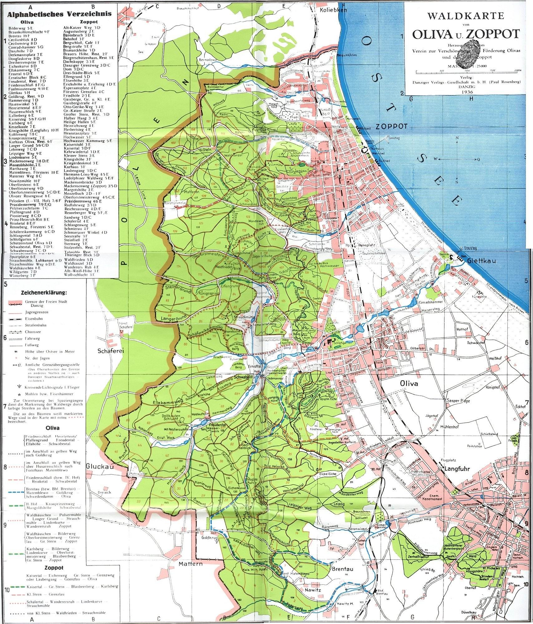
Paul Rosenberg, Waldkarte
von Oliva u. Zoppot, Danziger Verlags-Gesellschaft m.b.H
Links: Source / Biblio Ref
|
1936 | about 8 hours ago | 6 control points |

|
|
2026 | about 8 hours ago | 3 control points |

|
Links: Source / Biblio Ref
|
2026 | about 8 hours ago | 3 control points |

|
|
1977 | about 8 hours ago | 4 control points |

|
Links: Source / Biblio Ref
|
2026 | about 8 hours ago | 1 control point |

|
|
2026 | about 8 hours ago | Unrectified |

|
|
1973 | about 8 hours ago | 4 control points |

|
|
1961 | about 8 hours ago | 4 control points |

|
|
1960 | about 8 hours ago | 4 control points |

|
|
1960 | about 9 hours ago | 4 control points |

|
|
1960 | about 9 hours ago | 4 control points |

|
|
1963 | about 12 hours ago | 4 control points |

|
|
1970 | about 12 hours ago | 4 control points |

|
|
1976 | about 12 hours ago | 4 control points |

|
|
1956 | about 13 hours ago | 4 control points |

|
|
1960 | about 13 hours ago | 4 control points |

|
彰化縣福興鄉粘厝、福寶村一帶老地圖
|
1930 | about 13 hours ago | 4 control points |
|
|
|
2026 | about 14 hours ago | Unrectified |

|
|
1936 | about 15 hours ago | 34 control points |

|
|
2026 | about 18 hours ago | 5 control points |

|
|
2026 | about 18 hours ago | Unrectified |

|
|
2026 | about 18 hours ago | Unrectified |

|
|
2026 | about 18 hours ago | Unrectified |

|
|
2026 | about 18 hours ago | Unrectified |

|
|
2026 | about 18 hours ago | Unrectified |

|
|
2026 | about 18 hours ago | 3 control points |

|
|
2026 | about 18 hours ago | 7 control points |

|
|
2026 | about 19 hours ago | Unrectified |

|
|
2026 | about 20 hours ago | 3 control points |

|
(In 1 layer)
|
2026 | about 20 hours ago | 4 control points |

|
(In 1 layer)
|
2026 | about 20 hours ago | 5 control points |

|
|
2026 | about 21 hours ago | 5 control points |

|
Qajar Tehran map
|
2026 | about 21 hours ago | 1 control point |

|
|
2026 | about 23 hours ago | 3 control points |

|
|
2026 | about 23 hours ago | Unrectified |

|
|
2026 | about 24 hours ago | 5 control points |

|
|
1967 | about 24 hours ago | 18 control points |

|
|
2026 | about 24 hours ago | Unrectified |

|
|
1886 | 1 day ago | 10 control points |

|
|
2026 | 1 day ago | 1 control point |